Federal Agency: National Park Service (NPS)
Academic Institution: University of Nebraska-Lincoln (UNL)
NPS Project Manager: Christine Nycz, National Park Service, Midwest Archeological Center (MWAC)
Principal Investigator: Matthew Douglass, Department of Anthropology, University of Nebraska-Lincoln
MA Student: Jeremy Brunette, Department of Anthropology, University of Nebraska-Lincoln
Project Summary
Directed by Dr. Matthew Douglass, this project represents a collaborative effort between the University of Nebraska and the National Park Service, Midwest Archeological Center (MWAC), to inventory archaeological remains within the Chickasaw National Recreation Area in Murray County Oklahoma. As little information existed about cultural resources on the park, the primary object of the project was to provide a cursory assessment to help guide future management.
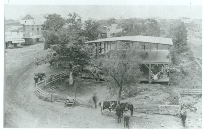
Early research into the history of the area indicated a need for focused investigation on the former town of Sulphur Springs, Indian Territory. Located within the modern park boundaries, this 19th Century town (Figure One) was strategically positioned around mineral and fresh-water springs in an attempt to create a health destination. Between 1902 and 1904, land was purchased to create a National Park, thus causing the town to relocate outside of park boundaries and resulting in the creation of the modern community of Sulphur, Oklahoma. Buildings within the new park were then relocated or demolished, and in the 1930's efforts to remove any trace of the former town were completed.
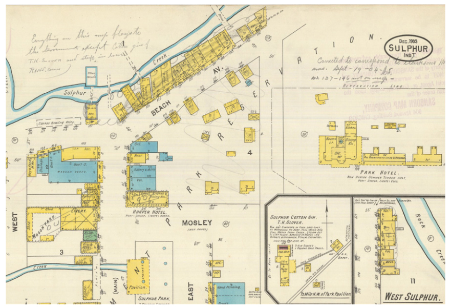
Detailed historic maps of blocks and buildings in the former town were located through archival research (Figure Two). Using LiDAR coverages of the current park, depressions and other landmarks were identified and used to georeference the historic map. Preliminary work was completed by MWAC archaeologist Christine Nycz and UNL graduate student Jeremy Brunette in 2014 and further refinement was completed by UNL graduate student Zach Day in 2015.
Using information encoded on the maps, as well as other archival findings, the team then developed a GIS displaying the location of over 300 former buildings with information on their function and previous owners (Figure Three). The team then completed surveys throughout the park using coordinates obtained from the GIS. This process, known as "ground truthing", helped to determine if remains of the former town could be identified in the modern park. Though the physical integrity of the building sites was quite limited, results of this ground truthing demonstrated quite conclusively that a substantial archaeological record remained throughout the park. At most locations where buildings had once stood, scatters of artifacts could be found thus reflecting the remains of the previous structures following abandonment and demolition.
Examination of remains at these locations (e.g. houses, hotels, and businesses) demonstrated a close agreement between the types of artifacts recovered and each building's function. Furthermore, several unique features including rock foundations, wells, and brick piles were also identified through these efforts. Documentation of these remains through digital photogrammetry (Video 1) provided a detailed record of their preservation and served as the basis for thesis research for another UNL graduate student, Michael Chodoronek, as well as a publication in the journal Advances in Archaeological Practice.
The information gained through this study provides a unique opportunity for community engagement. Though the town of Sulphur Springs is no more, its memory lives on. To support community interest in the projects, Brunette, Day, and Douglass worked with anthropology undergraduate students to produce a 3D virtual reconstruction of Sulphur Springs. The project was based on using information from historic maps and open source CAD software to reconstruct buildings which were then imported into the Unity Engine gaming software (Video 2). This initial reconstruction has since been shared with community members. Further development of more detailed models based on historic photos, provided by the community, as well as further refinements to the model's terrain, is now ongoing (Figure Five: Video Link). The approach developed through this student run project is now being replicated by other UNL faculty to complete additional reconstructions of archaeological sites.

Douglass, Chodoronek, Lin 2014 - Model 7 by unlarchaeology on Sketchfab
Video 1: Example of the photogrammetry models made of foundations and other features identified during ground truthing efforts. The model presented here depicts bricks from former buildings that were likely stacked in a ravine by Civilian Conservation Corps workers tasked with completing the final demolition of the former town of Sulphur Springs.
Video 2: Video Link to Unity Reconstruction. This video depicts an early version of the Sulphur Springs Reconstruction. The approach from GIS to 3D building reconstruction to videogame interfaced was developed through student projects completed by UNL undergraduate and graduate students. Further detail is now being added to develop the final model (see video example of generic models being replaced with detailed models based on photographs provided by local community members).